Stones That Still Draw the Line: A Two-Hour Boundary Walk from Borough to Waterloo
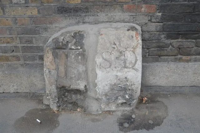
Photo: N Chadwick , CC BY-SA 2.0, via Wikimedia Commons
Parish boundaries are London's least glamorous relics. There is no gift shop, no audio guide, no helpful person in a tabard. Just a granite post half-hidden by a wheelie bin, or a cast-iron plate painted the same colour as the wall it sits on. And yet these lines did more to shape the streets you walk through than most of the monuments on the tourist trail.
This route follows one of the old divisions from Borough High Street to Waterloo. It is flat, about two and a half miles, and takes roughly two hours at a curious amble. You will not find a tidy trail of marked stones. What you will find is a line you can read in kerbs, brickwork, pub corners and the strange half-metre steps where terraces refuse to meet.
Why a line nobody can see still matters
Before London had a city-wide government, the parish did the practical work. It looked after the poor, maintained the roads, appointed the watch, and kept the weights and measures honest. Boundaries were not decorative. They decided who paid the rate and whose bell you heard on a Sunday.
The system was swept away in stages: the Metropolitan Board of Works in 1855, the metropolitan boroughs in 1900, the Greater London Council in 1965. But property deeds, drainage, pub licences and builders' habits have long memories. When a terrace stops half a brick short of its neighbour, or a street name changes for no obvious reason, a parish line is often the culprit.
The route at a glance
Start outside St George the Martyr on Borough High Street. Finish at Waterloo Station. Walk west via Marshalsea Road, Mint Street, Union Street, Waterloo Road, The Cut and Roupell Street. A paper A–Z is more useful than a phone here, because you are looking at walls, not screens.
Stop 1: St George the Martyr, Borough High Street
St George the Martyr was carved out of the older parish of St Saviour's in 1723, which makes it a useful place to start: a boundary created by an argument about money and pews. Stand by the churchyard wall and look for a low, weathered stone near the gate. The inscription is usually illegible by the time you find it, but the shape gives it away: a squat granite block, set slightly proud of the brick, doing a job that no longer exists.
The church itself is worth five minutes. Charles Dickens knew it as the church in Little Dorrit, and the Marshalsea debtors' prison once stood a few strides away. The parish line ran through a neighbourhood where liberty and debt were neighbours.
Stop 2: Mint Street and the Liberty of the Mint
Walk west along Marshalsea Road and turn into Mint Street. This was the Liberty of the Mint, a debtors' sanctuary where the ordinary rules of parish and City did not quite apply. People owing money could live here beyond the reach of their creditors, which made the place crowded, cheap and thoroughly disreputable.
The Mint's privileges were curtailed in the 1720s, but the name stuck. Look for boundary markers at the street corners: some are plain posts, some are plates set into walls, and some have been moved so often that they now mark nothing at all. That is part of the pleasure. The line is a rumour as much as a fact.
Stop 3: Union Street's tell-tale jog
Union Street runs broadly east–west towards Waterloo Road, and its name is a piece of nineteenth-century civic optimism. Walk its length and watch the shopfronts. Near the Waterloo Road end, the building line steps back by half a metre, then forward again. That is not a builder's error. It is the ghost of a parish boundary, where two estates developed at different times under different rules.
This is the sort of thing to look for all along the route: not a stone with a neat inscription, but a change in rhythm. Kerbs widen. Pavements change material. A terrace that has no reason to stop, stops.
Stop 4: Waterloo Road and the Old Vic
The Old Vic stands on the corner of Waterloo Road and The Cut, a theatre built in 1818 when this was a rough edge of Lambeth. The old parish line between Lambeth and Southwark runs close to Waterloo Road, and the modern borough boundary follows it for a stretch.
Look at the corner walls for painted plaques and cast-iron plates. Some carry initials; some carry dates; many have been overpainted so often that they read like abstract art. The Old Vic's own corner is a good place to think about how boundaries shape institutions. A theatre on the wrong side of a line could mean a different magistrates' court, a different licensing regime, a different set of neighbours with a different idea of a good night out.
Stop 5: Roupell Street and the brick change
Turn south into Roupell Street, one of the best-preserved early nineteenth-century terraces in London. John Roupell built it from the 1820s, and the street still has the tight, uniform look of a speculative development that knew exactly what it was doing.
At the corner where Roupell Street meets Theed Street, look for a low granite block set into the pavement. It may be a boundary stone; it may be a survivor of something else entirely. Either way, it sits on the line. The give-away is the brickwork above: a subtle change in colour and bond where one builder's plot ended and another's began.
Stop 6: York Road and Waterloo Station
Finish at the corner of York Road and Waterloo Road, near the station's older entrances. Waterloo opened in 1848 and swallowed streets, courts and boundary lines as it grew. A cast-iron plate near the York Road entrance is a reminder that the railway age did not erase the parish; it simply built over it.
Stand on the corner and look back towards the Old Vic. You have just walked a line that once decided who got poor relief and whose bell rang for curfew. Now it decides very little, which is exactly why it is worth following.
What you are looking for
Parish boundary markers come in several forms: granite posts, cast-iron plates, painted stones, and simple initials chiselled into a wall. Look at waist height and below, where paint and grime accumulate. Look at corners, gateposts and the ends of terraces. And look for the odd jog in the street: the boundary often survives as a change in building line rather than a single object.
Practical notes
Borough Market is the obvious place for coffee before you start, though it is busier on Saturdays than Sundays. The King's Arms on Roupell Street is a sensible halfway pint, and Waterloo Station has the toilets. Wear shoes you can walk two miles in, bring a torch in winter, and do not expect every stop to deliver a clear inscription. The line is the point, not the treasure.